We are happy to announce that the MuSe3D software that our company has been developing in the framework of the MuSe3D project supported by Research and Innovation Foundation (RIF) is finalised and enters the commercialisation phase.
![]()
The MuSe3D Application is developed GEORAMA and another Cypriot company GeoImaging Ltd in the framework of the MuSe3D EUREKA EUROSTARS project which aims to deliver a novel full system for multispectral 3D monitoring of vegetation with the use of UAVs available to you March 2021.
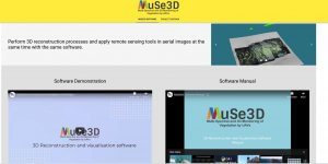
What is the MuSe3D App and what can it do for you?
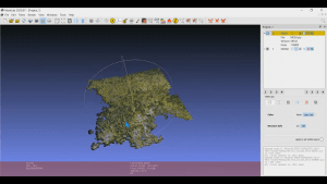
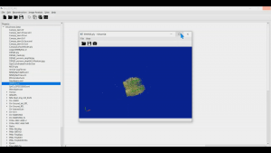
MuSe3D is an easy-to-follow application that allows the user to perform 3D reconstruction processes and apply remote sensing tools in aerial images under a clean and user-oriented interface, providing an overall better user experience. With the 3D Reconstruction suite, the user can generate sparse point cloud, dense point cloud and mesh, perform orthorectification and finally can calculate a DEM model. When used for image analysis, the remote sensing suite allows the user to apply vegetation indices in aerial multispectral images, such as:
- NDVI – Normalized Difference Vegetation Index
- GDVI – Green-Red Vegetation Index
- GNDVI – Green Normalized Difference Vegetation Index
- ENDVI – Enhanced Normalized Difference Vegetation Index
- GRVI – Green Ratio Vegetation Index
and allows to create a customised index.
The MuSe3D App comes as a projects and file management solution that enables the user to create, access and manage different and numerous projects as well as get notifications and guidance through the process.
If you like to test the app contact us or our partners at – www.geoimaging.com.cy to arrange for a full software demonstration
Developed by:
GEORAMA / GeoImaging
MuSe3D project overview
Main goal of the project is the development and evaluation of a novel multi-spectral measurement system for forestry and agriculture applications. The system will be small and light (less than 600 gram) so that it can be mounted on a UAV easily. The system is based on a measurement unit, a data streaming unit, and software for data interpretation. The system can easily be transported to critical points and collect data over short time intervals, delivering geo-referenced data which are stored and visualized in an adequate form.
Combination of multispectral image and 3D height measurement
The system consists of a measuring instrument, a data transmission unit and software for aerial image interpretation and classification. The measuring instrument is an integrated solution and consists of a multi-spectral camera, a 3D rangefinder, a processing unit and a time synchronization in a compact, lightweight housing. It can be easily transported to virtually any job site, and captures multispectral imagery and 3D geometries in a short time record, which can then be further processed and visualized as georeferenced 3D data.
Potential of Application
Data products to be derived include multispectral true-ortho photos and vegetation indices, as well as digital surface models and 3D visualizations. The combination of multispectral camera and 3D height measurement in a lightweight housing as well as a fully integrated evaluation process represent the innovation of the project. This system will allow to better estimate forest resources such as biomass, species composition and tree age as well as the health state of forests and agricultural crops.
The full system for multispectral 3D monitoring of vegetation with the use of UAVs available to you March 2021.
Partners
- Remote Sensing Solutions GmbH / Germany
- Fraunhofer IPM / Germany
- 4D-IT GmbH / Austria
- Georama LLC / Cyprus
- GeoImaging Ltd / Cyprus.
![]()